


Retailers:Autelpilot
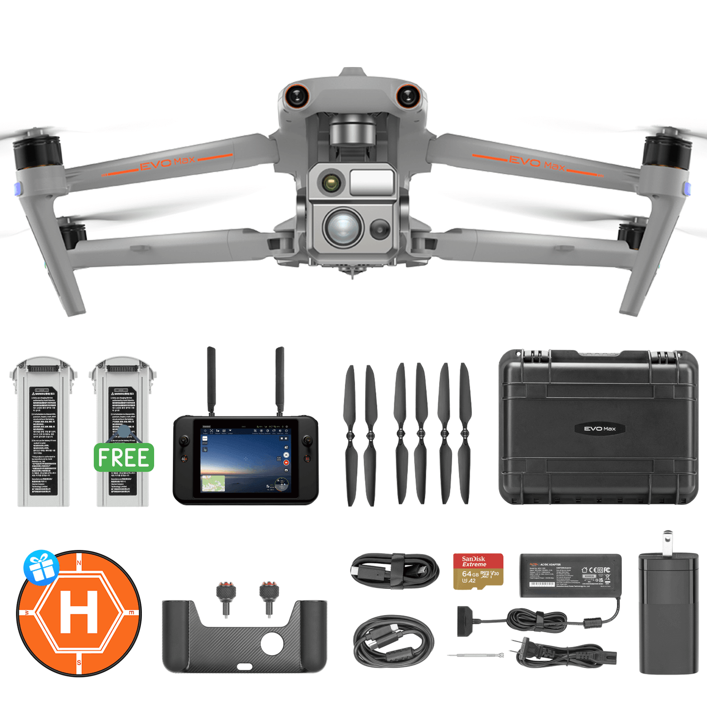
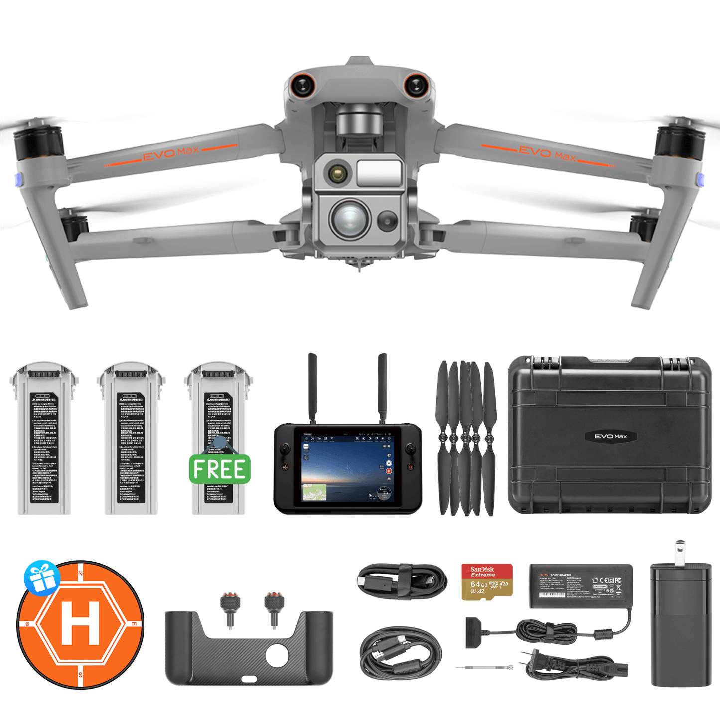
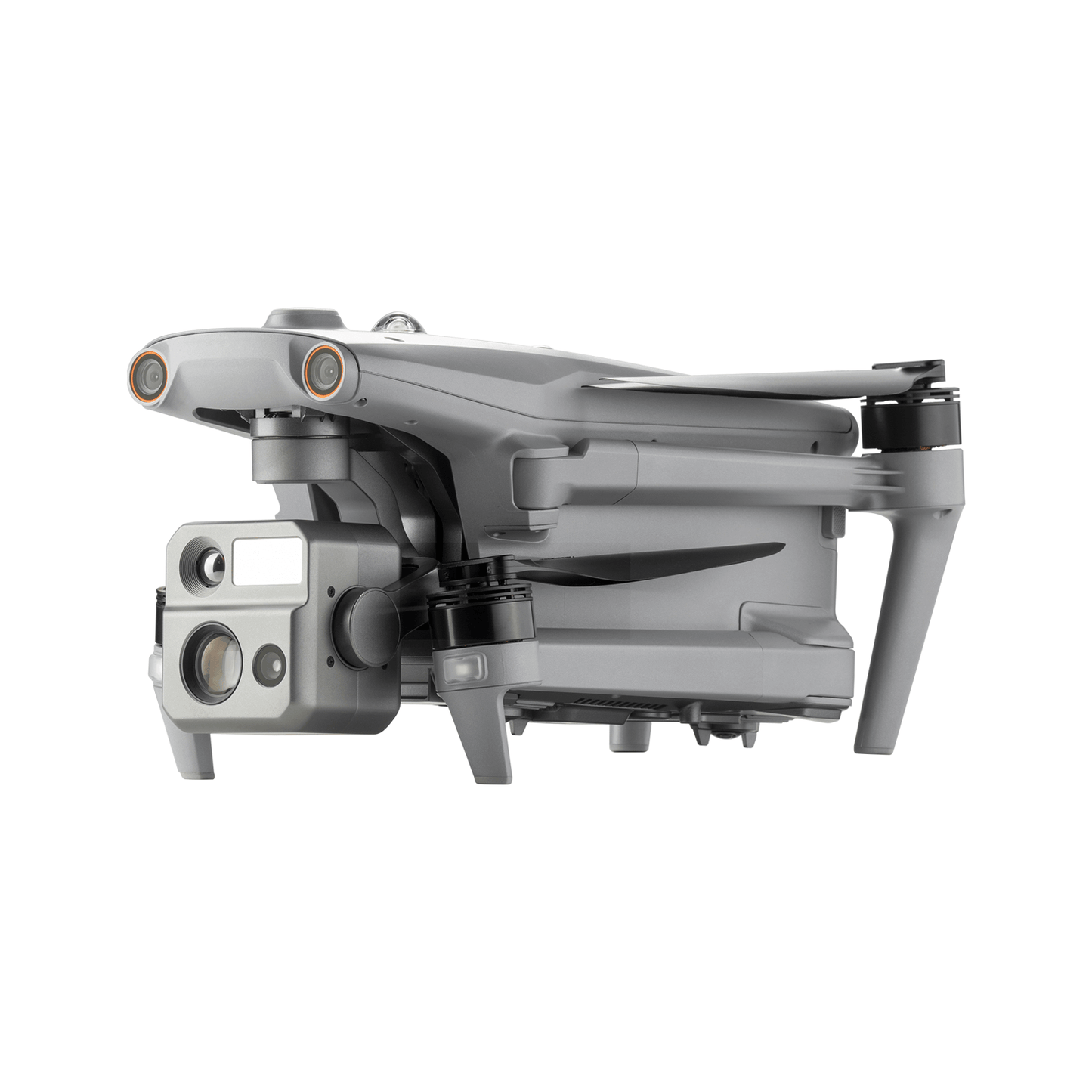
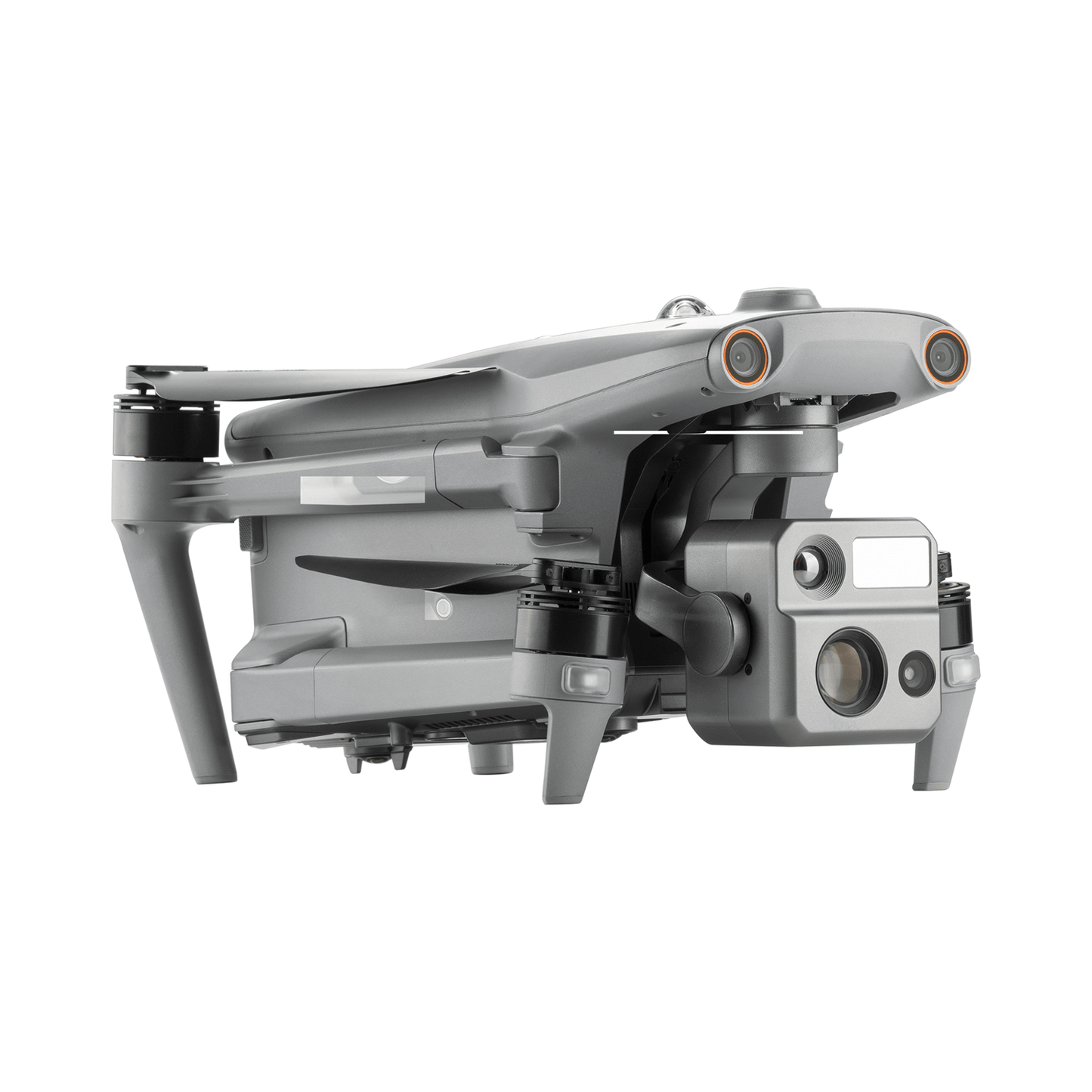
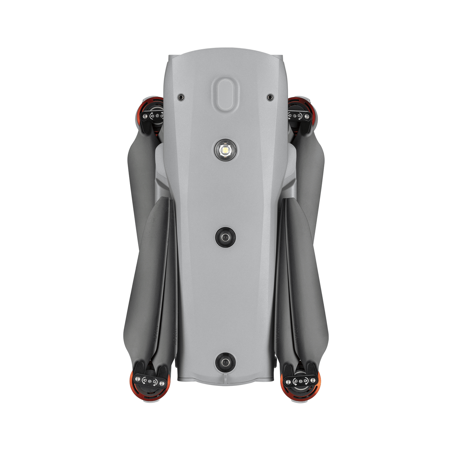
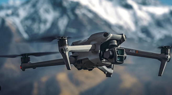
Autel Robotics EVO Max 4N Rugged Bundle
Autel Robotics EVO Max 4N Rugged Bundle
- One Complimentary Battery and Landing Pad
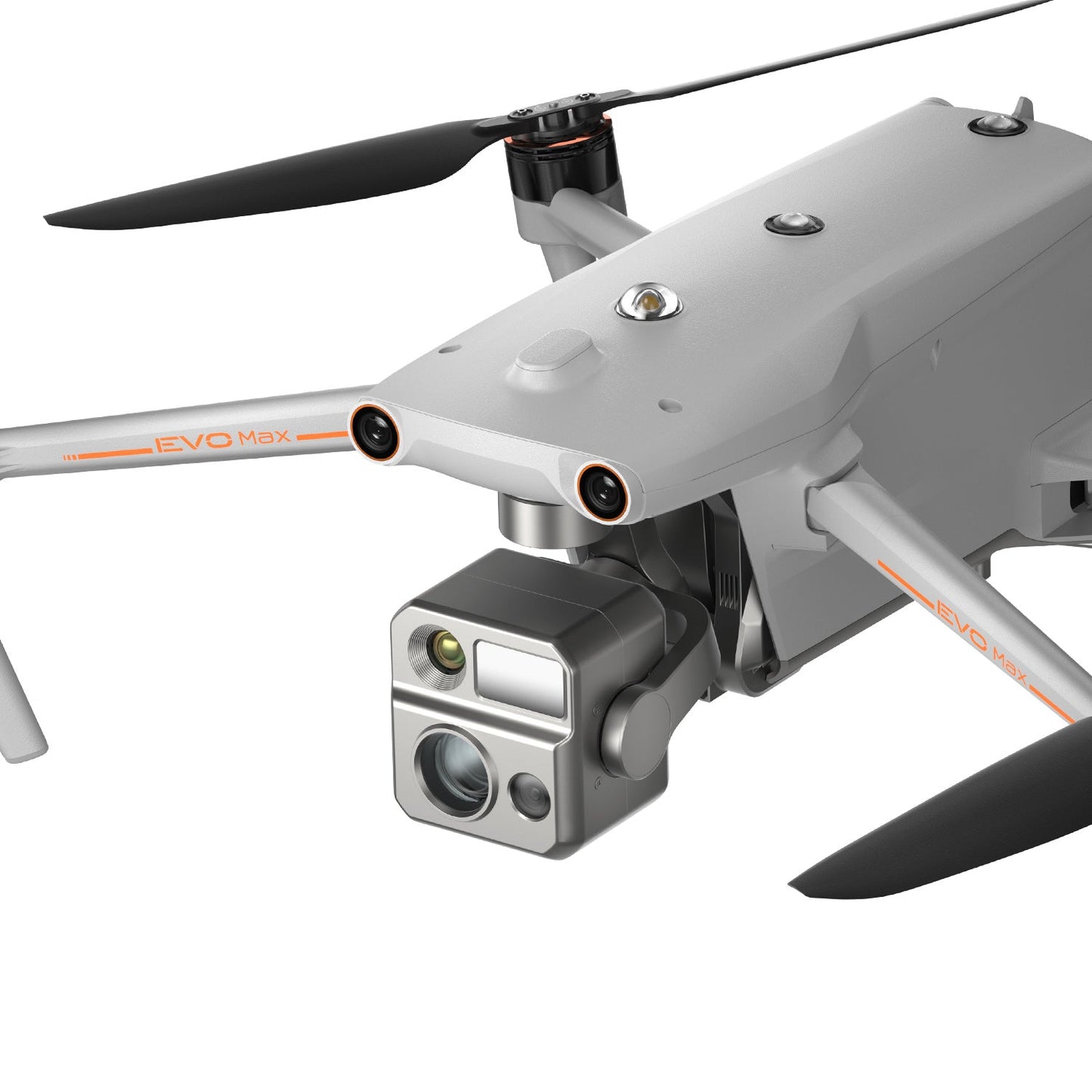
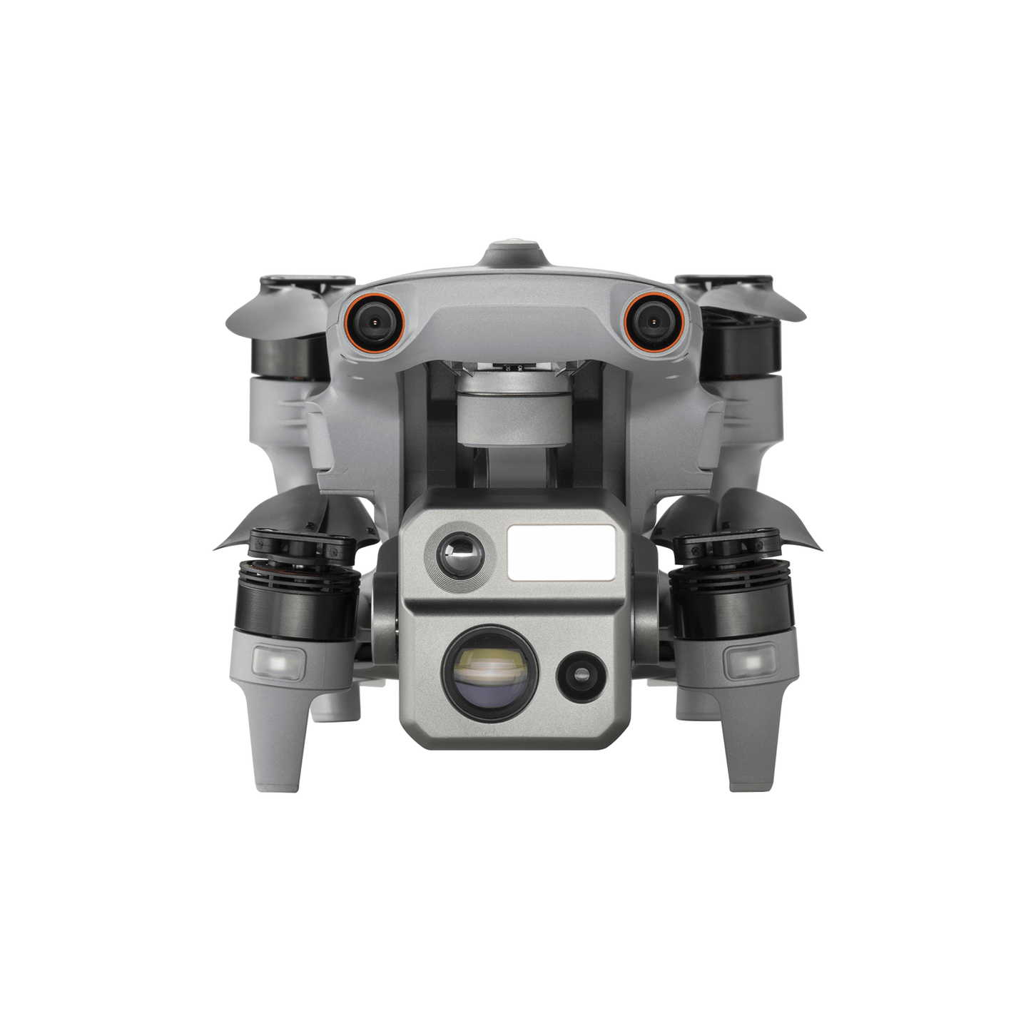
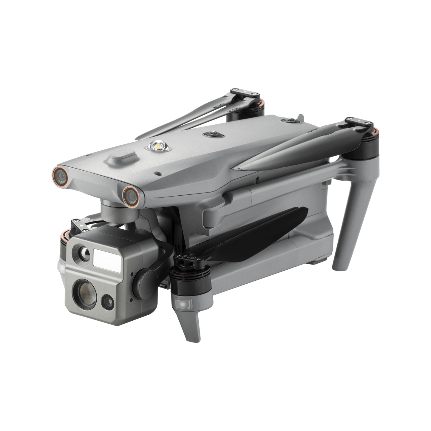
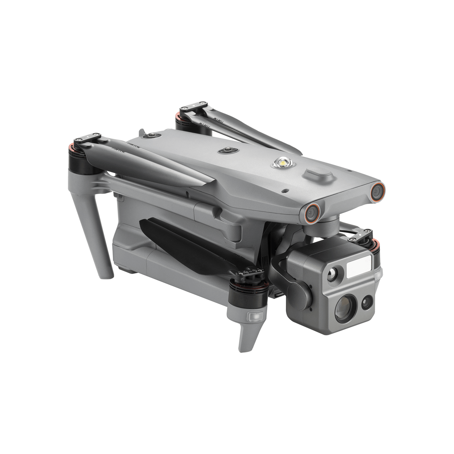
- Starlight Night-Vision Camera | as low as 0.0001 LUX and ISO ranges from 100-450,000
- Lock Targets & Track at Night
- Thermal Camera:640x512 | 16x Digital Zoom
- Wide Camera: 50MP | 1/1.28" CMOS
- Laser Rangefinder
- Autel SkyLink 3.0 | 12.4 miles Transmission Range
- 720° Obstacle Avoidance
- 42 mins Max Flight Time
- A-Mesh 1.0 | Mesh Networking Technology
- 3D Map Planning | Multiple Mission Types | Data Security
- Multi-channel Projection Screen*
- Autel SDK
[keyfeatures]
- Overview
- SPECS
- In the Box
- Documents
- Faqs
-
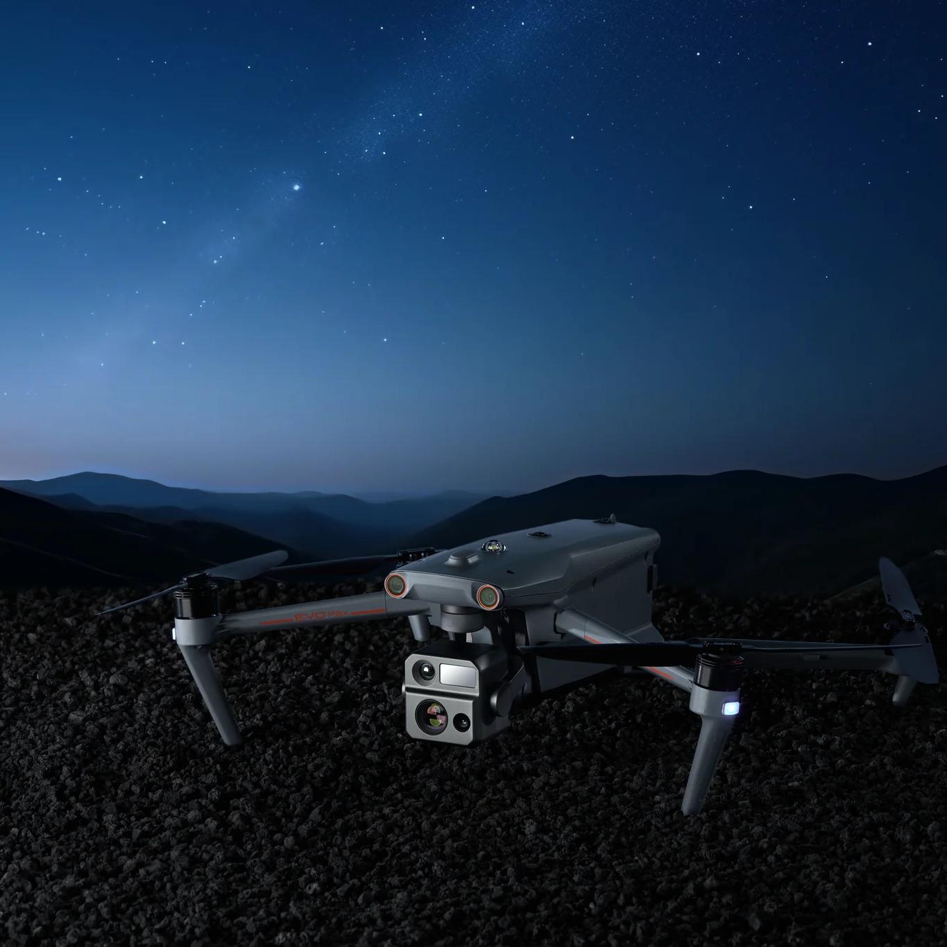
Autel EVO Max 4N - Explore the Night
Autel EVO Max 4N is the next generation of intelligent, agile drones, equipped with 720-degree obstacle avoidance and A-Mesh 1.0 networking support. This commercial drone is designed for night operations, featuring starlight night vision, zoom, thermal cameras, and full laser ranging capabilities. Autel EVO Max 4N's exceptional starlight camera allows it to operate in lighting conditions as low as 0.0001 Lux, delivering unparalleled performance in the dark. This makes it ideal for night surveys, emergency responses, and other critical missions that require superior visibility. With its advanced features and capabilities, Autel EVO Max 4N is the ultimate night-ops-ready drone for commercial applications.
-
-
Autonomous Path Finding Autel EVO Max 4N is powered by Autel's advanced Autonomy Engine, which collects surrounding environmental data and plans 3D flight paths through complex environments like mountains, forests, and buildings. This drone is ideal for a wide range of commercial applications, including rapid 3D scene reconstruction, public safety overwatch, industrial inspection, and land surveying.

-
-
-
Navigation in GPS Denied Environment Advanced sensors allow Autel EVO Max 4N to navigate within hardened structures, underground, or in environments without GPS.

-
-
-
Accurate Object Identification and Tracking Autel EVO Max 4N uses Autel's AI recognition technology to automatically identify and lock onto different types of targets such as heat sources, moving people, or vehicles. This enables the drone to achieve high-altitude tracking and data collection for law enforcement and other applications where reliable, real-time surveillance is crucial.

-
-
-
Autonomous Path Finding Autel EVO Max 4N is powered by Autel's advanced Autonomy Engine, which collects surrounding environmental data and plans 3D flight paths through complex environments like mountains, forests, and buildings. This drone is ideal for a wide range of commercial applications, including rapid 3D scene reconstruction, public safety overwatch, industrial inspection, and land surveying.
-
-
-
Navigation in GPS Denied Environment Advanced sensors allow Autel EVO Max 4N to navigate within hardened structures, underground, or in environments without GPS.
-
-
-
Accurate Object Identification and Tracking Autel EVO Max 4N uses Autel's AI recognition technology to automatically identify and lock onto different types of targets such as heat sources, moving people, or vehicles. This enables the drone to achieve high-altitude tracking and data collection for law enforcement and other applications where reliable, real-time surveillance is crucial.
-
No Blind Spots
Ultimate Obstacle Avoidance
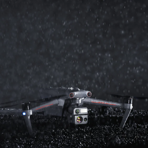
Autel EVO Max 4N is a unique commercial drone that combines traditional binocular vision systems with millimeter wave radar technology. This innovative combination enables the onboard Autel Autonomy Engine to detect objects as small as 0.5 inch, removing blind spots and allowing for operation in low light or rainy conditions.
Anti Jam, Anti Interference
Autel EVO Max 4N is equipped with advanced flight control modules and algorithms that are specifically designed to counter RFI, EMI, and GPS spoofing. This feature allows the drone to fly confidently near power lines, critical structures, and in complex areas, making it an ideal tool for industrial inspections, emergency response, and other critical operations.
Weather Rating-IP43

-
Anti Jam, Anti Interference
Autel EVO Max 4N is equipped with advanced flight control modules and algorithms that are specifically designed to counter RFI, EMI, and GPS spoofing. This feature allows the drone to fly confidently near power lines, critical structures, and in complex areas, making it an ideal tool for industrial inspections, emergency response, and other critical operations.
-
Weather Rating-IP43
Autel EVO Max 4N has an IP43 Ingress Protection rating, which means that it is protected against solid objects greater than 1mm in diameter and against sprays of water up to 60 degrees from the vertical. This makes the drone more durable and able to withstand challenging weather conditions, making it ideal for use in a wide range of applications.
Operation Temperature
-4 ℉ to 122 ℉
Platform Capability
EVO Max 4N redefines portability with its powerful platform and all weather design.
-
42 mins Max. Flight Time -
23,000 ft Service Ceiling -
12.4 miles Image Transmission Range -
27 mph* Max. Wind Resistance
-
42 mins Max. Flight Time -
23,000 ft Service Ceiling -
12.4 miles Image Transmission Range -
27 mph* Max. Wind Resistance

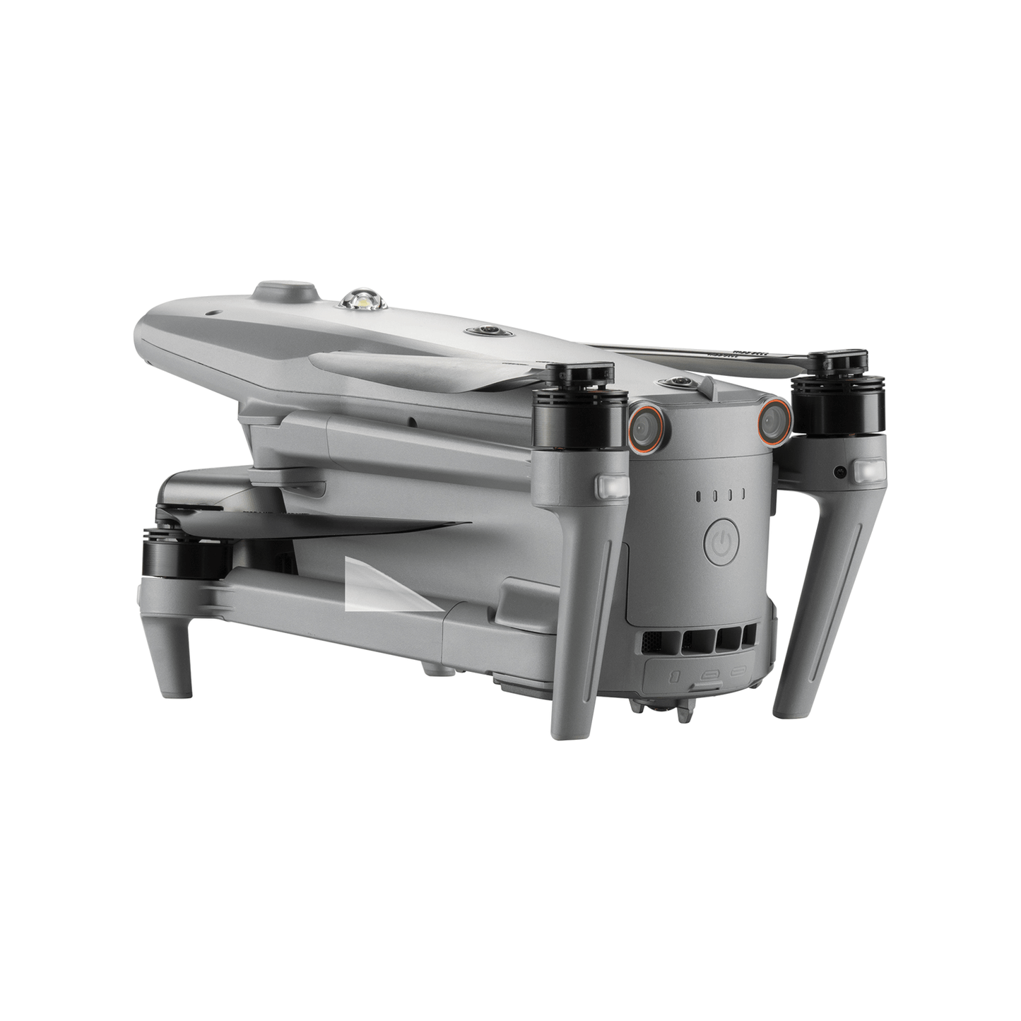
Hot-Swappable Battery
Autel EVO Max 4N features a hot-swappable battery system, allowing for extended flight times without any downtime. This innovative system enables users to easily swap out batteries while the drone is still in operation, thereby ensuring that there is no interruption to operations and making it ideal for use in time-critical applications where every second counts.
-
-
8070 mAh Capacity -
14.88V Voltage -
LiPo 4S Battery Type -
120wh Energy -
520g Net Weight -
Support Hot Swap
-

-
8070 mAh Capacity -
14.88V Voltage -
LiPo 4S Battery Type -
120wh Energy -
520g Net Weight -
Support Hot Swap
-
Autel Autonomy
EVO Max 4N is the only commercial drone that combines traditional binocular vision systems with millimeter wave radar technology, which enables the onboard Autel Autonomy Engine to detect objects as small as 0.5 inch, effectively eliminating blind spots and allowing operation in low light or rainy conditions.
-

Binocular Vision System -

Millimeter Wave Radar
-
-
Autel Autonomy
EVO Max 4N is the only commercial drone that combines traditional binocular vision systems with millimeter wave radar technology. This allows Autel EVO Max 4N's onboard Autel Autonomy Engine to perceive objects down to 0.5 inch, eliminating blind spots and enabling operation in low light or rainy conditions.
-
Binocular Vision System -
Millimeter Wave Radar
-
A-Mesh 1.0
The Drone Industry's First Mesh Networking Technology
EVO Max 4N features the new A-Mesh system, enabling drone-to-drone autonomous communication, connection, and collaboration.
-

-
Strong Anti-Interference Autel EVO Max 4N can communicate seamlessly with other drones in the vicinity, unlike a traditional chain structure. If a single drone fails or exits unexpectedly, the entire system will independently self-organize and continue to relay critical information.
-

-
Beyond-Line-of-Sight Applications The A-Mesh system in Autel EVO Max 4N allows multiple aircraft in the surrounding area to serve as relay points, significantly enhancing the effectiveness of operations beyond visual line of sight (BVLOS).
-
-
Full-Fleet Control Autel EVO Max 4N offers the capability to control multiple drones autonomously, either by a single pilot or by a group of pilots working simultaneously, with or without LTE coverage.
-

-
Enhanced Range Communication modes can be placed statically on hills or poles to provide full coverage to an area, or a swarm of drones can provide mobile communication points to extend the coverage of the entire group.
-
-
Strong Anti-Interference Autel EVO Max 4N can communicate seamlessly with other drones in the vicinity, unlike a traditional chain structure. If a single drone fails or exits unexpectedly, the entire system will independently self-organize and continue to relay critical information.
-
-
Beyond-Line-of-Sight Applications The A-Mesh system in Autel EVO Max 4N allows multiple aircraft in the surrounding area to serve as relay points, significantly enhancing the effectiveness of operations beyond visual line of sight (BVLOS).
-
-
Full-Fleet Control Autel EVO Max 4N offers the capability to control multiple drones autonomously, either by a single pilot or by a group of pilots working simultaneously, with or without LTE coverage.
-
-
Enhanced Range Communication nodes can be placed statically on hills or poles to provide full coverage to an area, or a swarm of drones can provide mobile communication points to extend the coverage of the entire group.
Autel SkyLink 3.0
Autel EVO Max 4N SkyLink 3.0 system comes with 6 antennas, 4 frequency bands, AES-256 encryption*, and optional 4G integration* to provide users with the most advanced flight capabilities ever in an EVO.
-
12.4 miles Image Transmission Distance -
<150ms Latency -
1080p/60fps Real-Time Image Quality -
900MHz/2.4GHz/5.2GHz/5.8GHz** Frequency Bands

-
12.4 miles Image Transmission Distance -
<150ms Latency -
1080p/60fps Real-Time Image Quality -
900MHz/2.4GHz/5.2GHz/5.8GHz** Frequency Bands
This feature will be available in a future update. **5.2GHz is only applicable for FCC, CE, and UKCA regions. 900MHz is only applicable for FCC regions.
Mission Ready Payload
The payload integrates wide-angle camera, zoom camera, thermal camera and a laser rangefinder for all data capture needs and critical decision making.
-
As low as 0.0001 Lux operate in lighting conditions -
Auto ISO100-ISO450000 Super Sensitive Mode -
50MP Wide Camera -
1/1.28 CMOS Wide Camera Sensor -
640x512 Thermal Resolution -
5m to 1.2km Laser Rangefinder Measuring Range
-
As low as 0.0001 Lux operate in lighting conditions -
Auto ISO100-ISO450000 Super Sensitive Mode -
50MP Wide Camera -
1/1.28 CMOS Wide Camera Sensor -
640x512 Thermal Resolution -
5m to 1.2km Laser Rangefinder Measuring Range

-

- Wide Camera
- 50MP
- 1/1.28" CMOS
- Aperture: f/1.9
- DFVO: 85°
- Equivalent: 23 mm
-

- Starlight Camera
- Effective Pixels: 2.3M
- Super Sensitive Mode: Auto ISO100-ISO450000
- Photo Resolution: 1920×1200
- Video Resolution: 20Mbps (1920×1200 P30)
- Zoom Range: 1-8x, supports linkage zoom
-

- Thermal Camera
- 640x512
- Aperture: 13mm
- 16x Digital Zoom
- Temperature Measurement
- Range: -4℉ to 302℉, 32℉ to 1022℉
-

- Laser Rangefinder
- Measuring Range: 5 - 1200m
- Measurement Accuracy: ± (1 m + D×0.15%) D is the distance to a vertical surface
Chase the Heat and Explore the Night
Autel Enterprise App Platform
Autel Enterprise App has been specifically designed for industrial applications, with a brand-new interface that streamlines operation and enhances usability. With additional features and semi-autonomous modes, the app maximizes Autel EVO Max 4N's mission capability, enabling efficient and effective operation in a wide range of scenarios.

Smart Features
-

-
3D Map Planning Plan, create, and execute 3D waypoint mission plan on a 3D map.
-

-
Quick Mission* Temporary quick missions can be created while executing other missions, and multiple sub-missions can be stacked for enhanced flexibility.
-

-
Mission Reproduction* With this feature activated, fly a manual or semi-autonomous mission, or string multiple missions together. Autel EVO Max4N will automatically record the camera angles and replicate the mission you just flew.
-
-
3D Map Planning Plan, create, and execute 3D waypoint mission plan on a 3D map.
-
-
Quick Mission* Temporary quick missions can be created while executing other missions, and multiple sub-missions can be stacked for enhanced flexibility.
-
-
Mission Reproduction* With this feature activated, fly a manual or semi-autonomous mission, or string multiple missions together. Autel EVO Max4N will automatically record the camera angles and replicate the mission you just flew.
Multiple Mission Types
Autel Enterprise App offers a range of autonomous and semi-autonomous mission planning capabilities for a variety of applications, including public safety, inspection, and surveying.
-

-
Spiral Mission* Supports helical flight search in a designated area for SAR.
-

-
Vertical Scan* Perform vertical surveys for building facades, open pit walls, and towers.
-

-
Corridor Mission* Supports intuitive and effective corridor mission planning for roads, rivers, pipelines, power lines and other narrow,large-scale terrain.
-

-
Polygon Mission Supports one-click automatic generation of polygon flight areas.
-

-
Terrain Follow* Maintain relatively constant altitude from the ground for uneven or sloped terrain.
-

-
Rectangular Mission Supports one-click automatic generation of a rectangular flight area.
-
-
Spiral Mission* Supports helical flight search in a designated area for SAR.
-
-
Vertical Scan* Perform vertical surveys for building facades, open pit walls, and towers.
-
-
Corridor Mission* Supports intuitive and effective corridor mission planning for roads, rivers, pipelines, power lines and other narrow,large-scale terrain.
-
-
Polygon Mission Supports one-click automatic generation of polygon flight areas.
-
-
Terrain Follow* Maintain relatively constant altitude from the ground for uneven or sloped terrain.
-
-
Rectangular Mission Supports one-click automatic generation of a rectangular flight area.
Data Security
Privacy Protection: Data involving user and aircraft information, including flight logs, locations, and account information can only be physically accessed via the aircraft locally.
Encrypted Data Storage: Supports AES-256 encryption for photos, videos, and flight logs, are password-protected.

Complete Remote Operations System
Used with Autel EVO Nest, Autel EVO Max series supports all-weather auto piloting for scenarios such as substations, industrial parks, and rooftops.
Autel SDK
Autel SDK is open to the world, helping developers and partners reduce software and hardware development costs and jointly create a new industry ecosystem.

-
-

Mobile SDK -
Open UX SDK (iOS/Android) can directly call up the interactive interface.
-
-
-
Mobile SDK -
Open UX SDK (iOS/Android) can directly call up the interactive interface.
-
Accessories
-

-
Autel Smart Controller V3 Daylight Readable Display: 7.9 inches, 2000nit maximum brightness, 2048*1536 resolution. SuperDownload: Download footage from drone to mobile device at a maximum rate of 20MB/s. Functional Interface: HDMI ports allow connection to 3rd party displays or monitors. Ultra-Long Battery Life: Up to 4.5 hours of continuous operation. 2-hr fast charging from empty. Local Storage: Built-in 128G storage space allows 3rd party apps and mission media storage.
-

-
EVO Nest (optional) EVO Nest is a base for automatic take off, landing, charging, and mission planning for Autel EVO series. The Nest is designed for all-weather operation and uses a single-piece protective drum with fewer moving parts to simplify maintenance.
-

-
RTK Module (optional) Provides centimeter-accurate positioning data for mapping and reduces electromagnetic interference for flying near critical structures.
-
-
Autel Smart Controller V3 Daylight Readable Display: 7.9 inches, 2000nit maximum brightness, 2048*1536 resolution. SuperDownload: Download footage from drone to mobile device at a maximum rate of 20MB/s. Functional Interface: HDMI ports allow connection to 3rd party displays or monitors. Ultra-Long Battery Life: Up to 4.5 hours of continuous operation. 2-hr fast charging from empty. Local Storage: Built-in 128G storage space allows 3rd party apps and mission media storage.
-
-
EVO Nest (optional) EVO Nest is a base for automatic take off, landing, charging, and mission planning for Autel EVO series. The Nest is designed for all-weather operation and uses a single-piece protective drum with fewer moving parts to simplify maintenance.
-
-
RTK Module (optional) Provides centimeter-accurate positioning data for mapping and reduces electromagnetic interference for flying near critical structures.
-
-
Aircraft Gimbal Starlight Camera Wide Camera Thermal Camera Laser Range Finder Image Transmission Autonomy Millimeter-wave Radar Visual Sensing System 7.9-inch Smart Controller Battery Aircraft Gimbal Starlight Camera Wide Camera Thermal Camera Laser Range Finder Image Transmission Autonomy Millimeter-wave Radar Visual Sensing System 7.9-inch Smart Controller Battery Aircraft
Weight 3.62 lbs (1641g, battery and gimbal included) Dimensions 562*651*147 mm (unfolded, incl. propellers) 318*400*147 mm (unfolded, excl. propellers) 257*145*131 mm (folded, excl. propellers) Diagonal Wheelbase 1.53 ft (466mm) Max Ascent Speed 8m/s Max Descent Speed 6m/s Max Horizontal Speed (windless near sea level) 23m/s *Maximum speed in Ludicrous Mode is 19m/s when operating in EU regions. Max Service Ceiling Above Sea Level 13,124ft (4000m) Max Flight Time (windless) 42 mins Max Hovering Time (windless) 38 mins Max Wind Resistance 27mph* *Takeoff and landing can withstand wind speeds up to 27 mph (12 m/s).
IP Rating IP43 Max Tilt Angle 35° Max Angular Velocity Pitch: 300°/s; Yaw: 120°/s Operating Temperature -4°F to 122°F (-20℃ - 50℃) Operating Frequency 2.4GHz/5.8GHz 5.2GHz (only applicable for FCC, CE, and UKCA regions). 900MHz (only applicable for FCC regions). GNSS GPS+Galileo+BeiDou+GLONASS Transmitter Power (EIRP) 2.4GHz: <30dBm (FCC), <20dBm(CE/SRRC/MIC) 5.8GHz: <27dBm (FCC/SRRC), <14dBm (CE) 5.15-5.25GHz: <23dBm (FCC/CE) 902-928MHz: <30dBm (FCC) 5.65-5.755GHz: <27dBm (MIC) Hovering Accuracy Vertical: ±0.1 m (Vision System enabled); ±0.3 m (GPS enabled); ±0.15 m (RTK enabled); Horizontal: ±0.15 m (Vision System enabled); ±0.3 m (GPS enabled); Wi-Fi Protocol 802.11a/b/g/n/ac/ax Support 2 x 2 MIMO Wi-Fi Wi-Fi Operating Frequency 2.400 - 2.4835 GHz; 5.150 - 5.250GHz (CE/FCC/MIC); 5.725 ‒ 5.850 GHz*(Except MIC) Wi-Fi Transmitter Power (EIRP) 2.400 - 2.4835 GHz FCC:<30dBm; CE/SRRC/MIC:<20dBm 5.150 - 5.250GHz FCC/CE/MIC<22dBm 5.725 ‒ 5.850 GHz FCC/SRRC: <21dBm CE: <14dBm Gimbal
Mechanical Range Pan: -135° to 45° Tilt: -45° to 45° Roll: -100° to 100° Controllable Range -90° to 45° Stable system 3-axis mechanical gimbal (pitch, tilt, roll) Max Control Speed (pitch) 200º/s Angular Vibration Range <0.005° Starlight Camera
Sensor Effective Pixels: 2.3M Lens Focal Length: 35mm (equivalent 41.4mm) FOV:52° Zoom Range: 1-8x, supports linkage zoom ISO Range Auto: ISO100-ISO450000 Super Sensitive Mode: Auto ISO100-ISO450000 Camera Modes Single shot (default), long press for continuous shots Photo Format JPG Photo Resolution 1920×1200 Video Format MP4 Video Resolution 20Mbps (1920×1200 P30) HDR Video Auto Video Output Super Sensitive Mode: 1920×1200 P30 Wide Camera
Sensor 1/1.28 CMOS, Effective pixels: 50M Lens DFOV: 85° Focal length: 4.5 mm (equivalent: 23 mm) Aperture: f/1.9 AF motor: 8-wire SMA, PDAF focus Exposure Compensation ±3EV 0.3EV/step ISO Range Auto: Photo: ISO100~ISO6400 Video: ISO100~ISO64000 (Night scene mode: up to ISO64000) Manual: Photo: ISO100~ISO12800 Video: ISO100~ISO6400 Shutter Speed Photo: 8s ~ 1/8000s Video: 1s ~ 1/8000s Max. Video Resolution 3840×2160 Photo Size 8192*6144 4096*3072 Thermal Camera
Thermal Imager Uncooled VOx Microbolometer Lens DFOV: 64°
Aperture: 13mm
Focus: f/1.2Infrared Temperature Measurement
Accuracy26.6~37.4 ℉ or reading ±3% (using
the larger value) @ambient
temperature -4℉ to 140℉Video Resolution 640*512 Photo Size 640*512 Pixel Pitch 12 um Temperature Measurement Method Center measurement, pot measurement, rectangular measurement Temperature Measurement Range -4℉ to 302℉, 32℉ to 1022℉ (-20°C to
150°C, 0 to 550°C)Temperature Alert High and low temperature alarm thresholds, reporting coordinates and temperaturevalues Laser Range Finder
Measurement Accuracy ± (1 m + D×0.15%) D is the distance to a vertical surface Measuring Range 5m to 1.2km Image Transmission
Operating Frequency 2.4G/5.2G*/5.8G/900MHz* Max Transmission Distance (unobstructed, free of interference) 20km Independent Networking 7.9-inch Smart Controller Transmitter Power (EIRP) 2.4GHz:<33dBm(FCC), <20dBm(CE/SRRC/MIC) 5.8GHz:<33dBm(FCC), <30dBm(SRRC), <14dBm(CE) 5.15-5.25GHz: <23dBm(FCC/SRRC/MIC) Autonomy
Non-GPS Hovering and Manual Flight Indoor: Horizontal error ≤3cm (At least have texture at one direction) Outdoor: Daytime: Within 500m flight height, horizontal error < 0.01*height Night: Manual flight is controllable within 100m flight height Non-GPS Return-to-Home Within 500m flight height, horizontal error of Return-to-Home point < 30cm Automatic Obstacle Rerouting High Speed Obstacle Rerouting: Flight speed up to 20m/s when Min. safety distance to obstacle is 1.5m High Precision Obstacle Rerouting: Flight speed could reach 3m/s when Min. safety distance to obstacle is 0.2m Multi-target Recognition and Tracking Target identification types: people, vehicles, boats Number of targets detected: 64 Comprehensive recognition accuracy: > 85% Millimeter-wave Radar
Frequency 60Ghz~64Ghz Size 38*14*2mm Weight 2g EIRP 18dbm Distance Detection Range For Obstacle Avoidance:0.2m~100m For Height Measurement:0.05m~200m Ranging Accuracy For Obstacle Avoidance:0.1m For Height Measurement:0.02m Speed Measurement Range ± 60m/s(4D Mode);±28m/s(3D Mode); Speed Measurement Accuracy ≤1% Max. Tracking Target Number 32 Visual Sensing System
Obstacle Sensing Range Forward/Upward/Downward/Backward/Sideward: 0.2~50m FOV Forward/Backward/Sideward: 60°(H),80°(V) Upward/Downward: 360°(H),190°(V) 7.9-inch smart controller
Screen 7.9 inch, 2000nits max. brightness, 2048*1536 resolution External Battery Capacity: 5800mAh Voltage: 11.55V Battery Type: Li-on Energy: 67Wh Charing time: 120mins Intelligent Lithium Ion Battery Operating Time 3 hours (Max. brightness) 4.5 hours (50% brightness) Max Transmission Distance (with interference) FCC: 20km CE: 7km Storage 128G GNSS GPS+GLONASS+Galileo+Beidou Operating Temperature -20℃ to 40℃ Protocol WiFi Direct, Wi-Fi Display, 802.11a/b/g/n/ac Support 2 x 2 MIMO Wi-Fi Operating Frequency 2.400 - 2.4835 GHz; 5.150 - 5.250GHz; 5.725 ‒ 5.850 GHz Transmitter Power (EIRP) 2.400 - 2.4835 GHz FCC/CE:≤20dBm 5.150 - 5.250GHz FCC:≤17dBm 5.725 ‒ 5.850 GHz FCC:≤17dBm CE:≤14dBm Aircraft Battery
Capacity 8070mAh Voltage 14.88V Battery Type LiPo 4S Energy 120wh Net Weight 520g Charging Temperature 5ºC to 45ºC(When the temperature is lower than 10° C (50° F), the selfheating function will be automatically enabled. Charging in a low temperature may shorten the lifetime of the battery) Hot Swap Support -
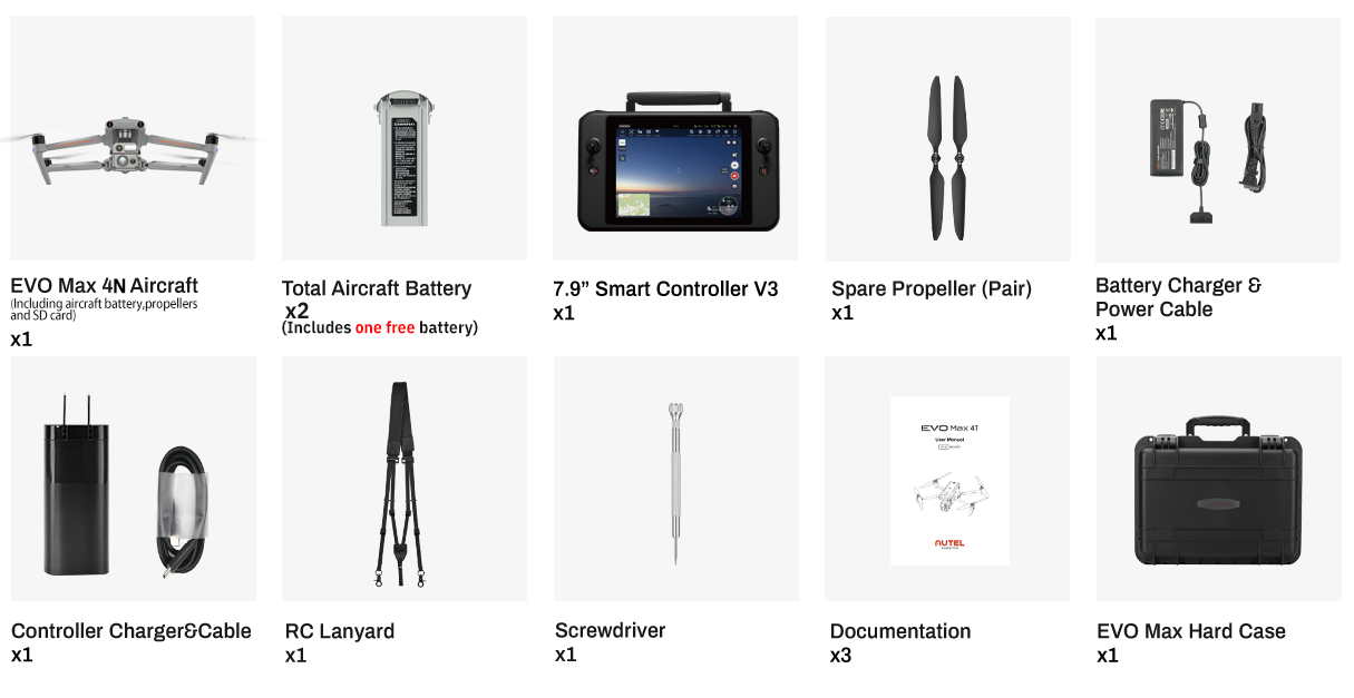
Autel EVO Max 4N Package List
-
Name
Download EVO Max Series Brochure - EN.pdf
EVO Max 4N One-Sheet.pdf
EVO Max 4N Specification
-
Autel Robotics EVO MAX Series Quick Questions & Quick Answers
Q: What is the major difference between EVO Max 4N and EVO Max 4T?
Q: What's the maximum flight time of EVO Max Series?
Q: What are the updates to SkyLink 3.0 compared with SkyLink 2.0?
Q: Is Autel EVO Max Series dust and water resistant?
Q: What's the difference between the 4D mode and 3D mode of Autel EVO Max Series millimeter wave radar?
Q: Will the aircraft fall off if the GPS system fails?
Q: What are the precautions for daily use?
Q: Can I fly the aircraft indoors?
Q: Is the aircraft waterproof?
Q: What's the transmission range between remote controller and aircraft?
Q: How many frequencies does the remote controller support?
Q: What is the capacity and energy of a single battery?
Q: How does the battery self-heating work?
Q: Can I use the batteries of EVO Max 4N for EVO Max 4T, or the other way around?
Q: What is the capacity and energy of a single battery?
Q: Can the remote controller of EVO Max 4N be used for EVO Max 4T and Autel EVO II series?
Q: Can the payload be replaced?
Q: What payloads are supported?
Q: What scenarios can EVO Max 4N apply to?
Q: Which industries can it be applied to?


Let customers speak for us
So far I love this fitness tracker. I was mainly interested in my sleep and stress level and this is pretty cool to see the data. I was curious how it compared to my apple watch as far as steps, etc and it's surprisingly similar to my watch. The app is super easy to use and customize and I've had no negative issues with it at all. I read some reviews that said the app was problematic but I've had no problems with it. I love how long this stays charged, much easier to use for health tracking than my watch. I keep it on for everything except my shower. I love the choice of bands that came with it, there are three to choose from and they are highly adjustable. I have a fairly small wrist and it cinches up small enough without being bulky. There are a variety of band colors to choose from so this could be worn even with dressy clothes and be minimally noticed if you get a neutrally light colored band. I highly recommend this fitness tracker. It may not be 'medically accurate' but it's a good option to see basic results and have somewhat of a baseline. I've included some of the screen shots of the app options and features, each one of those lines takes you to a specific screen for that feature. All data is displayed in one easy to read page. One of the neatest features is the ability to generate a 'health score report' that is AI generated and extremely detailed. I wish I could include a photo of it but it's personal data so I won't share; just know that it is one of the best features this device has. Again, not a substitute for any medical information or diagnosis; but still very valuable information that I have found to be very accurate for me.
About a week in, mainly using it for sleep, all day activity, and heart rate trends. I used Pixel Watch mainly for sleep and heart rate, as a reference.
What works: it's light enough that I genuinely forget it's on overnight, more than I can say for my Pixel Watch, which always felt awkward to sleep in. Sleep duration and heart rate matched the Watch closely across the week, close enough that I trust the trends. The AI summary is a nice touch, though I'd love charts in a future version, not just text.
Battery: 80% after 1 week use. (I will come back to update)
What doesn't: the app is little bit cluttered overwhelming at first (if you not familiar with Android permissions). A few labels are ambiguous: there's a "Disconnect" button that reads like a status indicator until you tap it and find it's actually an action. I understand some of that is Android's own UI conventions, I expect the UI get more polished further down the road. A tiered easy/intermediate/advanced UI would help. Waiting to see new update :)
Bottom line: solid 4.5 stars. Worth it if you want a sleep friendly screenless tracker and can stomach a busy app on day one.

I’ve been using this fitness tracker for a bit now, and it’s been a great addition to my routine. Setup was quick, and it paired with my phone easily.
The health tracking is impressive for the price—heart rate, sleep, and blood oxygen all provide useful insights for everyday fitness goals. Battery life is a standout, lasting for a really long time!
It’s also lightweight and comfortable enough to wear all day and even while sleeping. Overall, it’s a reliable, feature-packed tracker that offers excellent value without breaking the bank.
Exactly what I want in a fitness tracker and more. I primarily wanted this to track my heart rate during workouts and quality sleep. I cross check this with other trackers and sensors seem to be accurate. I like that it comes with different straps of differing materials. I use the fabric strap most of the time but when working out I use the neoprene/silcone strap so it doesn't absorb sweat.
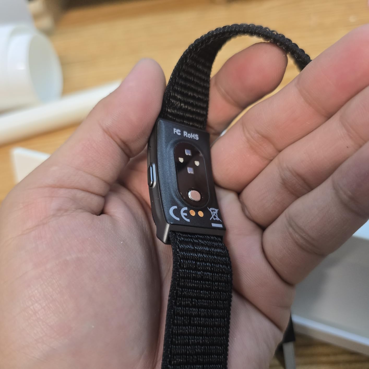
I Never regret to choose this. I love how comfortable to wear everyday. Very light. 4days now since I started using it and only 12% of the battery is used. Just download the apps and you will monitor everything there.

VERY impressed with these. the “Hey Cyan” AI assistant is genuinely cool and super helpful. the voice sounds natural and conversational, similar to Alexa or Gemini, and it responds quickly. the photo and video quality is better than expected, and the battery life is insanely good. the AI can describe what you’re looking at and recognize objects, which is really impressive. my only complaint is that the instructions didn’t clearly explain how to add the sunglasses lenses, and there were two different apps listed. i personally preferred the HeyCyan app and found it worked best overall. despite that small confusion, these glasses are extremely impressive. They are a bit heavy but once you're wearing them you tend to even forget that you have them on! color is nice and just black and it's a GREAT value for your money especially in comparison to other brands that do the exact same thing. Comfortable to wear for longer periods of time.
As a guy who is a master at technology, and already BOUGHT & RETURNED the most expensive pair of RAYBANS Smart Glasses, these are amazing! So much better! The light is insanely bright but also can be covered for convenience! Great POV! Slight tilt up and battery pretty good good value for money functions amazingly and has many features! Connectivity comes easy! I connect with my IOS and Android!
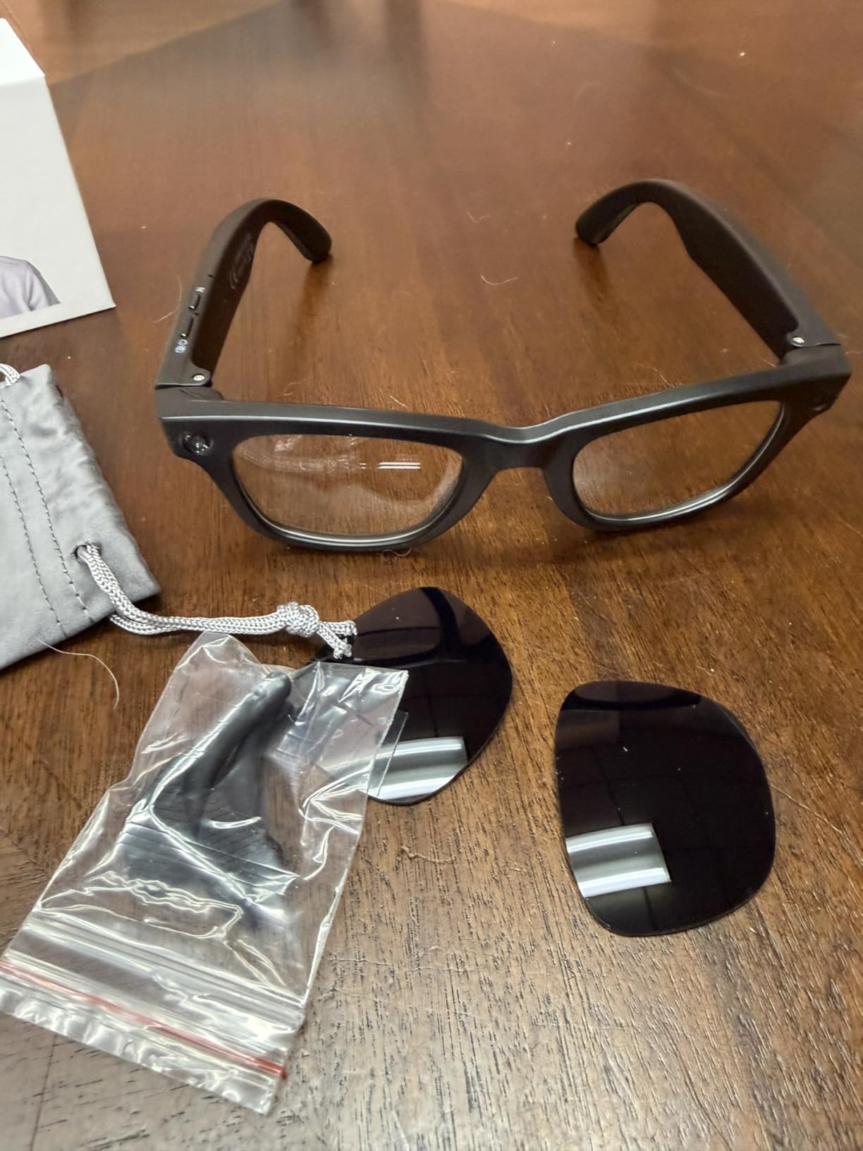
These ZekNeo smart glasses arrived faster than expected, and the real-time translation has been the standout part so far. I tested them during a quick chat with someone speaking Spanish, and it picked up both sides of the conversation smoothly, showing the text right in the lens while speaking the translation out loud. It handled casual talk and even some faster dialogue without too much delay, which made things feel natural instead of awkward. The 100+ languages claim seems legit based on what I've tried.
The camera takes solid 4K video and clear 8MP photos with almost no shake, even when I'm walking around outside. Transferring files over WiFi to my phone is quick and easy, so sharing clips or pics doesn't take forever. The open-ear audio sounds surprisingly good for music and calls, and the noise-canceling mics pick up my voice clearly even with some background noise. The photochromic lenses shift tint nicely when I go from indoors to bright sunlight, and they feel comfortable for longer wear without pressing on my nose or ears.
Battery holds up well through a full day of mixed use—music, a few calls, some photos, and translation sessions—and the IP66 rating gives peace of mind if it rains or I get sweaty. They're not the fanciest design, but they're sturdy, lightweight, and practical for everyday stuff. Overall, these have been way more useful than I thought they'd be. 👍🚀

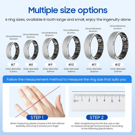
I was suprised how well it fit. How accurate each one of the vitails were. I have an finger O2 moniterdoing, several test were ran to check accuracy. The ring data matched perfectly. I love how easy the app is to useI would definitey recommend this smart ring to otheres
Love it works wonderful
I love this ring! It works great and lets you track your blood pressure as you sleep as well as throughout the day. The sleep tracking is super accurate. Because it's an enamel finish it is very durable and hasn't lost any of its color after several months.
Bought for my girlfriend and she loves it. The only time she isnt wearing it is when its charging

Great for the price !

Ok so I have only had this ring for 24 hours, but let me tell you… it is amazing! 🤩 the fit is perfect, it is a little smaller than the normal size of a regular ring so take that in mind. I have been wearing it since I got it, battery hasn’t hardly moved. No it doesn’t connect to Apple health or I imagine androids version of health but it has its own app. This one doesn’t has a subscription fee, it also does almost everything the $400 ring does, tracks blood pressure, heart rate, oxygen, your steps, sleep pattern. I have a problem with low blood pressure, I pass out because of it, this helps me check it before I go do something or while standing so I know to sit before I do. it’s 100% but it was pretty close when we checked against my machine.
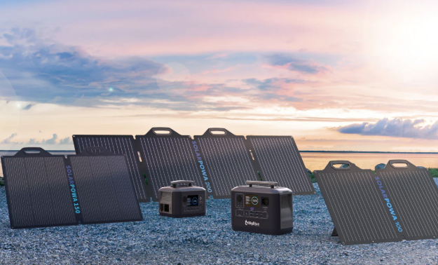
Hot Products
-
BKC × ZekNeo Smart Ring,Featuring Stress and Sleep Monitoring Functions, Compatible with iOS and Android,Waterproof Fitness Tracker(No Subscription)
Продавец:BKCОбычная цена $19.99Обычная ценаЦена за единицу за$49.99Цена со скидкой $19.99Распродажа -
BKC × ZekNeo Enamel Craft Smart Ring,Fitness Tracker with Heart Rate, SpO2, Blood Pressure & Sleep Monitoring, IP68 Waterproof (No Subscription)
Продавец:BKCОбычная цена $29.99Обычная ценаЦена за единицу за$79.99Цена со скидкой $29.99Распродажа -
BKC × ZekNeo Smart Bracelet with 24/7 Activity & Sleep Tracking, Heart Rate, Blood Oxygen, HRV & Stress Monitor, GPS Modes(No Subscription)
Продавец:BKCОбычная цена $39.99Обычная ценаЦена за единицу за$139.00Цена со скидкой $39.99Распродажа -
BKC × ZekNeo AI Smart Glasses with 8MP Camera, 1080P Video & HD Photo, Bluetooth Audio, AI Voice Assistant, Real-Time Translation, Object Recognition(No Subscription)
Продавец:BKCОбычная цена $69.99Обычная ценаЦена за единицу за$199.99Цена со скидкой $69.99Распродажа


Blog Posts
Посмотреть все-

Luna Ring Gen 2 review: Making some waves
A solid—but not groundbreaking—subscription-free smart ring The Noise Luna Ring Gen 2 is a thoroughly solid wearable that hits the high notes of sleep and readiness tracking without the burden...
Luna Ring Gen 2 review: Making some waves
A solid—but not groundbreaking—subscription-free smart ring The Noise Luna Ring Gen 2 is a thoroughly solid wearable that hits the high notes of sleep and readiness tracking without the burden...
-

Polar Loop (Gen 2) review: Lost in the shuffle
A well-built tracker in desperate need of a friendlier app The Polar Loop (Gen 2) is a solid piece of hardware, but it's by no means a straightforward subscription-free alternative...
Polar Loop (Gen 2) review: Lost in the shuffle
A well-built tracker in desperate need of a friendlier app The Polar Loop (Gen 2) is a solid piece of hardware, but it's by no means a straightforward subscription-free alternative...
-

Amazfit T-Rex 3 Pro review: The value adventurer
Premium, trail-ready hardware—with software often lagging behind The Amazfit T-Rex 3 Pro is a hardware triumph that offers an almost unbelievable spec sheet for half the price of a Garmin...
Amazfit T-Rex 3 Pro review: The value adventurer
Premium, trail-ready hardware—with software often lagging behind The Amazfit T-Rex 3 Pro is a hardware triumph that offers an almost unbelievable spec sheet for half the price of a Garmin...


Shop By Category
-

BKC Strictly Selected
BKC platform selects the best suppliers from tens of millions of products...

BEST SELLERS


